Vulnerability
Dominica, located in the Eastern Caribbean, is in a unique geographic location subjected to many natural disasters. Climate change only further threatens Dominica's climate vulnerability. Due to the island's climate vulnerability, the economy constantly faces threats due to natural disasters. Dominica's small economy thus experiences significant economic vulnerability.

Scott's Head shot by Daniella Rolle
Climate Vulnerability
The Caribbean region simultaneously possesses both beauty and danger. It sits along a hurricane beltway, producing many hurricanes, especially in the Eastern Caribbean islands. The Climate Execution Agency of Dominica (CREAD) released the Climate Resilience Recovery Plan that helped to explain Dominica's climate vulnerability, based on its unique geographic location. Many countries in the region are also sitting along a subduction zone between the Caribbean and North American tectonic plates which produces the risk of seismic activity. The region is also home to numerous large volcanoes with Dominica having nine, and four of them being active. Under normal circumstances, it is hard to build sustainable infrastructure when at any moment you must consider hurricanes, earthquakes, volcanic eruptions, tsunamis, and tropical storms. Climate change only makes infrastructure planning more complex, and challenges communities to respond.
Figure 1 Projected Temperature Increases in the Caribbean under global 2.5 degrees Celsius and 1.5 - 2 degree Celsius warming. Sourced from CREAD Climate Resilience and Recovery Plan Report (2020)

Figure 3 Change in Temperature from 1850 to 2018. Sourced from IPCC Land Report (2019)
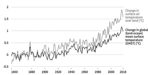
The mean temperature in both air and ocean surface has changed more than 0.5 degrees Celsius over the past half-century, indicating colossal climate change for the Caribbean. Alongside the shift in temperature, the frequency and intensity of tropical storms and hurricanes in the Atlantic Ocean have also changed.
Figure 3 Frequency of Climatic Events from 1900 to 2008. Sourced from CREAD Climate Resilience and Recovery Plan Report (2020)

Figure 4 Accumulated Cyclone Index (ACE) helps to determine the frequency and duration of storms. Sourced from CREAD Climate Resilience and Recovery Plan Report (2020)

In the figure above, storms classified as above normal in frequency and duration, which were outliers in the past have now slowly become the new normal .
These effects are coupled with rising sea levels at 1.7 to1.9 mm per annum and annual total rainfalls projected to decrease by up to 30%. Changes in sea level and rainfall projections are immensely impactful for both risks of flooding and vegetation loss, due to less rainfall, which can increase the chances of slope erosion. According to the Patkins and Mazzi Composite Index, Dominica is the fourth most vulnerable island in the Caribbean.

Cocoa Factory shot by Daniella Rolle
Economic Vulnerability as A Small-Island Developing State (SID)
- GDP Growth
- Monetary Impact of Natural Disasters
- Insurance Challenges
- Net Export
Figure 5 Progression of Dominica's growth since becoming an independent state. Data provided by the World Bank

Dominica experienced its most transformational growth between 1978 and 1988. After this decade, the growth rate has not been as steady — except for 2003 to 2008 when there was consistently high growth.
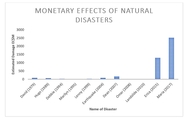
One of the significant disrupters of Dominica's economic growth are natural disasters. Fred L. Odgen in his research detailed the impacts of Tropical Storm Erika on Dominica. Tropical storm Erika surprisingly hit Dominica on August 17, 2015, leaving many unprepared. The intense rainfall on Dominica's steep slopes, rugged terrain, and thin soils caused the most significant flooding since Hurricane David in 1979. The storm killed numerous people, caused landslides, and substantially damaged infrastructure.
Figure 6 This figure provides an isight on the damage natural disasters have inflicted on the island. It also reflects the intensity of the storms and how it has evolved over nearly the past 3 decades. Sourced from CREAD Climate Resilience and Recovery Plan Report (2020)

Figure 7 Another visual aid to demonstrate the financial cost of major natural disasters. Data sourced from Central Statisitcs Dominica